Global Drone Application Map Tool Market Size is valued at US$ 941.9 Mn in 2024 and is predicted to reach US$ 6,428.7 Mn by the year 2034 at an 21.5% CAGR during the forecast period for 2025-2034.
A drone application map tool, also known as a drone mapping tool or software, is a specialized application designed to process aerial data collected by unmanned aerial vehicles (UAVs or drones). It is a tailored software platform that interprets aerial data acquired by drones for use in a number of agricultural and environmental applications.

It provides exact input application mapping for fertilizers and pesticides, directs aerial seeding and replanting by generating terrain-aware maps, and aids agricultural scouting and vegetation monitoring by analyzing plant health using RGB and multispectral images. The program also helps with irrigation and water stress mapping by identifying drought or overwatered regions, assuring regulatory compliance by providing necessary documentation and spray records, and livestock monitoring by tracking animal movement and distribution. By combining these various use cases on a single platform, the tool improves efficiency, sustainability, and data-driven decision-making in modern agricultural and land management.
The growing need for accurate, real-time mapping in various industries is another factor driving the drone application map tool market forward. This growing need for accurate, real-time mapping in agriculture industries is driving the drone application map tool market through accurate surveys, efficient resource management, and faster decisions, safety, and productivity. According to the U.S. Department of Agriculture (USDA), the five states leading the adoption of precision agriculture technologies - North Dakota, Nebraska, Iowa, South Dakota, and Illinois - accounted for nearly one-half of the 2022 U.S. cash receipts for fieldcrops. However, growth in the drone application map tool market is hindered by challenges that include strict regulations, the capital-intensive nature of equipment, limited battery life, data privacy concerns, and a shortage of skilled drone operators and analysts. During the forecast period, opportunities will arise for the drone application map tool market through increased adoption in agriculture, construction, mining, and disaster management, as well as advancements in AI, LiDAR, and integrated analytics.
Some of the Key Players in Drone Application Map Tool Market:
· Pix4D SA
· DroneDeploy, Inc.
· Agisoft LLC (Metashape)
· Sentera, Inc.
· Environmental Systems Research Inst. (ESRI)
· Aerobotics (Pty) Ltd
· Hummingbird Technologies Ltd
· Hiphen Technologies
· Farmonaut
· OpenDroneMap, Inc. (open-source)
· SPH Engineering LLC (UgCS)
· DroneMapper LLC
· Maps Made Easy, Inc.
· SimActive Inc.
· FlyPard Analytics GmbH
The drone application map tool market is segmented use-case application, software, integration level, deployment model, and business model. By use-case application, the market is segmented into input application mapping, aerial seeding and replanting guidance, crop scouting and vegetation monitoring, irrigation and water stress mapping, regulatory compliance and documentation, and livestock monitoring. By software, the market is segmented into application map generation tools, mission planning and execution software, compliance and traceability software, and drone-based agronomic analytics software. By integration level, the market is segmented into standalone mapping tools, and integrated farm management systems. By deployment model, the market is segmented into cloud-based platforms, and on-premises/desktop software. By business model, the market is segmented into software-as-a-service (subscription), pay-per-use (per acre or per flight), and enterprise licensing and service contracts.
The input application mapping category led the drone application map tool market in 2024. This convergence is fueled by its essential use in precision agriculture, construction, and infrastructure management. The input application mapping is necessary for the precise delineation of a field or site, enabling efficient resource allocation through advanced planning by combining drone-derived geospatial information with AI and GIS systems. The segment can provide real-time, actionable management and reduce operational costs, increase productivity, and minimise human error. Its use and application are not limited to agriculture, construction, and infrastructure, but can also be applied in various industries. Therefore, the rise in demand for data-driven decision-making and smart operations, along with increased application and management across multiple sectors, drives the need for sustained market dominance.
The largest and fastest-growing software is application map generation tools, which are used in precision agriculture, urban planning, mining, and disaster management, where the delivery of mapping, crop health surveillance, and site inspection technologies can be automated. Adoption has been rapid due to the ease of use, AI-assisted workflows, and the ability to serve a wide range of drone platforms, which enhances decision-making by reducing the time required to interpret survey data to seconds. The aggregate achievement of the software in terms of eliminating manual labour, increasing the accuracy of manual data, and providing scalability to the operations will contribute to its largest market share.
North America dominated the drone application map tool market in 2024. The United States is at the forefront of this expansion. This is due to the early implementation of leading UAV technologies, reliable infrastructure, and existing industries such as construction, agriculture, and mining. Supportive government regulation, investment in smart city, and demand for precision mapping and surveying products also contribute to market leadership. The presence of key drone manufacturers and technology innovators also helps the region maintain its market leadership.
With swift industrialisation, urbanisation, and infrastructure in the Asia-Pacific area, the drone application map tool market is expanding at the strongest and fastest rate in this region. The rising adoption of drones in agriculture, mining, and disaster management, along with supportive government regulations, advances in technology, and increasing investments in smart city and precision agriculture projects, further propel growth. Furthermore, the growing awareness of the benefits of drone mapping for various applications, coupled with the region’s considerable untapped markets, is expected to accelerate very high growth.
Drone Application Map Tool Market by Use-Case Application-
· Input Application Mapping
· Aerial Seeding and Replanting Guidance
· Crop Scouting and Vegetation Monitoring
· Irrigation and Water Stress Mapping
· Regulatory Compliance and Documentation
· Livestock Monitoring

Drone Application Map Tool Market by Software-
· Application Map Generation Tools
· Mission Planning and Execution Software
· Compliance and Traceability Software
· Drone-Based Agronomic Analytics Software
Drone Application Map Tool Market by Integration Level-
· Standalone Mapping Tools
· Integrated Farm Management Systems
Drone Application Map Tool Market by Deployment Model-
· Cloud-Based Platforms
· On-Premises/Desktop Software
Drone Application Map Tool Market by Business Model-
· Software-as-a-Service (Subscription)
· Pay-Per-Use (Per Acre or Per Flight)
· Enterprise Licensing and Service Contracts
Drone Application Map Tool Market by Region-
North America-
· The US
· Canada
Europe-
· Germany
· The UK
· France
· Italy
· Spain
· Rest of Europe
Asia-Pacific-
· China
· Japan
· India
· South Korea
· Southeast Asia
· Rest of Asia Pacific
Latin America-
· Brazil
· Argentina
· Mexico
· Rest of Latin America
Middle East & Africa-
· GCC Countries
· South Africa
· Rest of the Middle East and Africa
This study employed a multi-step, mixed-method research approach that integrates:
This approach ensures a balanced and validated understanding of both macro- and micro-level market factors influencing the market.
Secondary research for this study involved the collection, review, and analysis of publicly available and paid data sources to build the initial fact base, understand historical market behaviour, identify data gaps, and refine the hypotheses for primary research.
Secondary data for the market study was gathered from multiple credible sources, including:
These sources were used to compile historical data, market volumes/prices, industry trends, technological developments, and competitive insights.

Primary research was conducted to validate secondary data, understand real-time market dynamics, capture price points and adoption trends, and verify the assumptions used in the market modelling.
Primary interviews for this study involved:
Interviews were conducted via:
Primary insights were incorporated into demand modelling, pricing analysis, technology evaluation, and market share estimation.
All collected data were processed and normalized to ensure consistency and comparability across regions and time frames.
The data validation process included:
This ensured that the dataset used for modelling was clean, robust, and reliable.
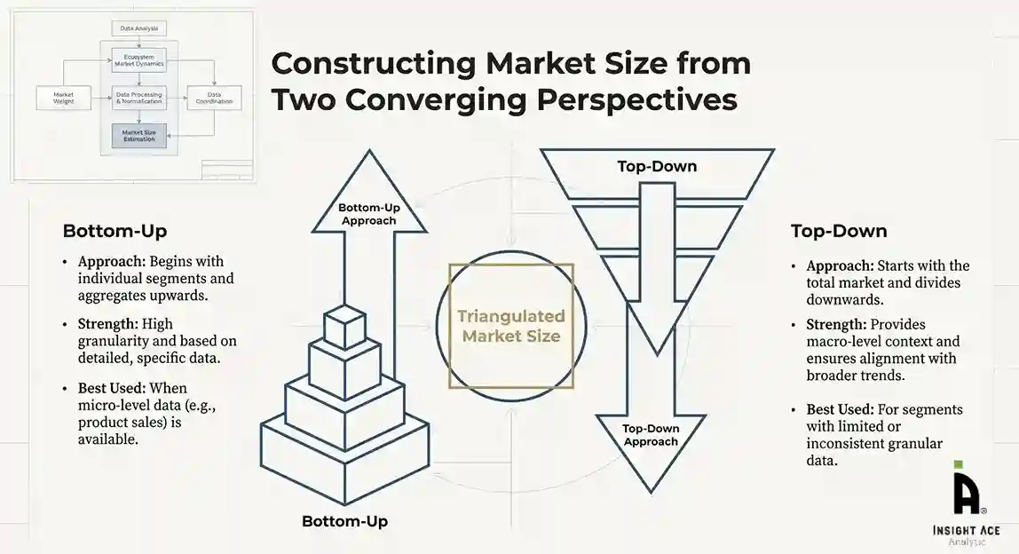
The bottom-up approach involved aggregating segment-level data, such as:
This method was primarily used when detailed micro-level market data were available.

The top-down approach used macro-level indicators:
This approach was used for segments where granular data were limited or inconsistent.
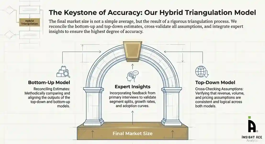
To ensure accuracy, a triangulated hybrid model was used. This included:
This multi-angle validation yielded the final market size.
Market forecasts were developed using a combination of time-series modelling, adoption curve analysis, and driver-based forecasting tools.
Given inherent uncertainties, three scenarios were constructed:
Sensitivity testing was conducted on key variables, including pricing, demand elasticity, and regional adoption.