Global Satellite Imaging for Agriculture Market Size is valued at USD 588.1 Mn in 2024 and is predicted to reach USD 1359.0 Mn by the year 2034 at an 8.9% CAGR during the forecast period for 2025-2034.
Remote sensing, or satellite imaging, is a powerful technology rapidly utilized in agriculture to monitor and manage crop health, optimize resource allocation, and improve overall agricultural practices. Satellite imagery gives farmers a complete picture of agricultural fields, allowing them to monitor crop health, growth, and development throughout the growing season.

The agricultural satellite imaging industry is expanding rapidly, driven by a variety of factors. Precision farming techniques, which rely on satellite imaging, are gaining popularity as farmers attempt to optimize resource allocation and boost production. The utilization of satellite data for crop health monitoring, finding variability within fields, and enabling variable rate applications is increasing demand for agricultural satellite imaging solutions. The availability of high-quality and high-frequency satellite imaging allows more timely and accurate crop monitoring, which improves agricultural decision-making.
However, the epidemic has resulted in financial hardships and spending restrictions for many farmers and agricultural enterprises. Limitations in investment capacity have been caused by decreased incomes, disrupted supply networks, and financial uncertainty. As a result, some farmers would postpone or scale down their expenditures in satellite imaging technologies and related services, which would have an effect on market expansion.
Satellite imaging for the agriculture market is segmented on the basis of application, end-user, and product. Application segment includes crop health monitoring, soil mapping, forestry, and others. The end-user segment includes agribusinesses, government and non-government agencies, research institutes, and others. By product, the market is segmented into data acquisition, processing, analytics, and integrated delivery platform.
The crop health monitoring category is expected to hold a major share in the global satellite imaging for agriculture market in 2024. Satellite imaging in agriculture is crucial for crop health monitoring. Farmers can make educated decisions about irrigation, fertilization, and pest control thanks to the valuable information provided by satellite images for evaluating the health and vigor of crops. Areas of agricultural stress, such as those caused by water stress, nutritional deficits, or pest infestations, can be found using satellite photography. Farmers can identify variances and identify areas that need care by monitoring vegetation indices over time and comparing them to reference values.
The agribusiness segment is projected to grow at a rapid rate in the global satellite imaging for the agriculture market. The agricultural satellite imaging market is significant to the agribusiness industry. Farming, crop production, agrochemicals, seed production, agricultural machinery, and other operations are all included in agribusinesses. Agribusinesses can gain a lot from satellite imaging technology, which helps companies increase productivity, streamline processes, and make wise decisions. Agribusinesses may monitor crop health and growth throughout the growing season using satellite photography.
The North America Satellite Imaging for Agriculture Market is expected to register the highest market share in terms of revenue in the near future. A significant and growing sector of the agriculture industry in North America is satellite imaging for agriculture. Numerous farms, sophisticated farming methods, and a high level of technological adoption can all be found in North America.
Market growth has been influenced by a number of factors, including the growing use of precision agriculture technology, the demand for increased production, and the emphasis on environmentally friendly practices. More farmers and agribusinesses are likely to realize the advantages of satellite imaging in maximizing agricultural operations, which will lead to further market expansion. A significant sector of the region's agricultural market is the Europe satellite imaging for agriculture market. With a strong emphasis on sustainable practices, precision agriculture, and technology breakthroughs, Europe has a broad and substantial agricultural sector.
|
Report Attribute |
Specifications |
|
Market size value in 2024 |
USD 588.1 Mn |
|
Revenue forecast in 2034 |
USD 1359.0 Mn |
|
Growth rate CAGR |
CAGR of 8.9% from 2025 to 2034 |
|
Quantitative units |
Representation of revenue in US$ Mn,, and CAGR from 2025 to 2034 |
|
Historic Year |
2021 to 2024 |
|
Forecast Year |
2025-2034 |
|
Report coverage |
The forecast of revenue, the position of the company, the competitive market statistics, growth prospects, and trends |
|
Segments covered |
Application, End-User, And Product |
|
Regional scope |
North America; Europe; Asia Pacific; Latin America; Middle East & Africa |
|
Country scope |
U.S.; Canada; U.K.; Germany; China; India; Japan; Brazil; Mexico; The UK; France; Italy; Spain; China; Japan; India; South Korea; Southeast Asia; South Korea; Southeast Asia |
|
Competitive Landscape |
Airbus, Farmers Edge Inc, Planet Labs PBC, Satellogic, Syngenta, Maxar Technologies, Descartes Labs, Inc, EOS Data Analytics, Inc, Esri, European Space Imaging, Gamaya, ICEYE, NaraSpace Inc, Open Cosmos Ltd, Satellite Imaging Corporation, SkyWatch, SpaceKnow Inc., EarthDaily Analytics, SatSure, SpaceSense, Perspective. |
|
Customization scope |
Free customization report with the procurement of the report, Modifications to the regional and segment scope. Particular Geographic competitive landscape. |
|
Pricing and available payment methods |
Explore pricing alternatives that are customized to your particular study requirements. |
Chapter 1. Methodology and Scope
1.1. Research Methodology
1.2. Research Scope & Assumptions
Chapter 2. Executive Summary
Chapter 3. Global Satellite Imaging for Agriculture Market Snapshot
Chapter 4. Global Satellite Imaging for Agriculture Market Variables, Trends & Scope
4.1. Market Segmentation & Scope
4.2. Drivers
4.3. Challenges
4.4. Trends
4.5. Investment and Funding Analysis
4.6. Industry Analysis – Porter’s Five Forces Analysis
4.7. Competitive Landscape & Market Share Analysis
4.8. Impact of Covid-19 Analysis
Chapter 5. Market Segmentation 1: by Product Type Estimates & Trend Analysis
5.1. by Product Type & Market Share, 2024 & 2034
5.2. Market Size (Value (US$ Mn)) & Forecasts and Trend Analyses, 2021 to 2034 for the following by Product Type:
5.2.1. Data Acquisition
5.2.2. Processing
5.2.3. Analytics
5.2.4. Integrated Delivery Platform
Chapter 6. Market Segmentation 2: by End-user Estimates & Trend Analysis
6.1. by End-user & Market Share, 2024 & 2034
6.2. Market Size (Value (US$ Mn)) & Forecasts and Trend Analyses, 2021 to 2034 for the following by End-user:
6.2.1. Agribusinesses
6.2.2. Government and Non-Government Agencies
6.2.3. Research Institutes
6.2.4. Others
Chapter 7. Market Segmentation 3: by Application Estimates & Trend Analysis
7.1. by Application & Market Share, 2024 & 2034
7.2. Market Size (Value (US$ Mn)) & Forecasts and Trend Analyses, 2021 to 2034 for the following by Application:
7.2.1. Crop Health Monitoring
7.2.2. Soil Mapping
7.2.3. Forestry
7.2.4. Others
Chapter 8. Satellite Imaging for Agriculture Market Segmentation 4: Regional Estimates & Trend Analysis
8.1. North America
8.1.1. North America Satellite Imaging for Agriculture Market Revenue (US$ Million) Estimates and Forecasts by Product Type, 2021-2034
8.1.2. North America Satellite Imaging for Agriculture Market Revenue (US$ Million) Estimates and Forecasts by End-user, 2021-2034
8.1.3. North America Satellite Imaging for Agriculture Market Revenue (US$ Million) Estimates and Forecasts by Application, 2021-2034
8.1.4. North America Satellite Imaging for Agriculture Market Revenue (US$ Million) Estimates and Forecasts by country, 2021-2034
8.2. Europe
8.2.1. Europe Satellite Imaging for Agriculture Market Revenue (US$ Million) Estimates and Forecasts by Product Type, 2021-2034
8.2.2. Europe Satellite Imaging for Agriculture Market Revenue (US$ Million) Estimates and Forecasts by End-user, 2021-2034
8.2.3. Europe Satellite Imaging for Agriculture Market Revenue (US$ Million) Estimates and Forecasts by Application, 2021-2034
8.2.4. Europe Satellite Imaging for Agriculture Market Revenue (US$ Million) Estimates and Forecasts by country, 2021-2034
8.3. Asia Pacific
8.3.1. Asia Pacific Satellite Imaging for Agriculture Market Revenue (US$ Million) Estimates and Forecasts by Product Type, 2021-2034
8.3.2. Asia Pacific Satellite Imaging for Agriculture Market Revenue (US$ Million) Estimates and Forecasts by End-user, 2021-2034
8.3.3. Asia-Pacific Satellite Imaging for Agriculture Market Revenue (US$ Million) Estimates and Forecasts by Application, 2021-2034
8.3.4. Asia Pacific Satellite Imaging for Agriculture Market Revenue (US$ Million) Estimates and Forecasts by country, 2021-2034
8.4. Latin America
8.4.1. Latin America Satellite Imaging for Agriculture Market Revenue (US$ Million) Estimates and Forecasts by Product Type, 2021-2034
8.4.2. Latin America Satellite Imaging for Agriculture Market Revenue (US$ Million) Estimates and Forecasts by End-user, 2021-2034
8.4.3. Latin America Satellite Imaging for Agriculture Market Revenue (US$ Million) Estimates and Forecasts by Application, 2021-2034
8.4.4. Latin America Satellite Imaging for Agriculture Market Revenue (US$ Million) Estimates and Forecasts by country, 2021-2034
8.5. Middle East & Africa
8.5.1. Middle East & Africa Satellite Imaging for Agriculture Market Revenue (US$ Million) Estimates and Forecasts by Product Type, 2021-2034
8.5.2. Middle East & Africa Satellite Imaging for Agriculture Market Revenue (US$ Million) Estimates and Forecasts by End-user, 2021-2034
8.5.3. Middle East & Africa Satellite Imaging for Agriculture Market Revenue (US$ Million) Estimates and Forecasts by Application, 2021-2034
8.5.4. Middle East & Africa Satellite Imaging for Agriculture Market Revenue (US$ Million) Estimates and Forecasts by country, 2021-2034
Chapter 9. Competitive Landscape
9.1. Major Mergers and Acquisitions/Strategic Alliances
9.2. Company Profiles
9.2.1. Airbus
9.2.2. Farmers Edge Inc
9.2.3. Planet Labs PBC
9.2.4. Satellogic
9.2.5. Syngenta
9.2.6. Maxar Technologies
9.2.7. Descartes Labs, Inc
9.2.8. EOS Data Analytics, Inc
9.2.9. Esri
9.2.10. European Space Imaging
9.2.11. Gamaya
9.2.12. ICEYE
9.2.13. NaraSpace Inc
9.2.14. Open Cosmos Ltd
9.2.15. Satellite Imaging Corporation
9.2.16. SkyWatch
9.2.17. SpaceKnow Inc.
9.2.18. EarthDaily Analytics
9.2.19. SatSure
9.2.20. SpaceSense
9.2.21. Synspective
9.2.22. Other Prominent Players
Satellite Imaging for Agriculture Market By Application-
Satellite Imaging for Agriculture Market By End-User-

Satellite Imaging for Agriculture Market By Product-
Satellite Imaging for Agriculture Market By Region-
North America-
Europe-
Asia-Pacific-
Latin America-
Middle East & Africa-
InsightAce Analytic follows a standard and comprehensive market research methodology focused on offering the most accurate and precise market insights. The methods followed for all our market research studies include three significant steps – primary research, secondary research, and data modeling and analysis - to derive the current market size and forecast it over the forecast period. In this study, these three steps were used iteratively to generate valid data points (minimum deviation), which were cross-validated through multiple approaches mentioned below in the data modeling section.
Through secondary research methods, information on the market under study, its peer, and the parent market was collected. This information was then entered into data models. The resulted data points and insights were then validated by primary participants.
Based on additional insights from these primary participants, more directional efforts were put into doing secondary research and optimize data models. This process was repeated till all data models used in the study produced similar results (with minimum deviation). This way, this iterative process was able to generate the most accurate market numbers and qualitative insights.
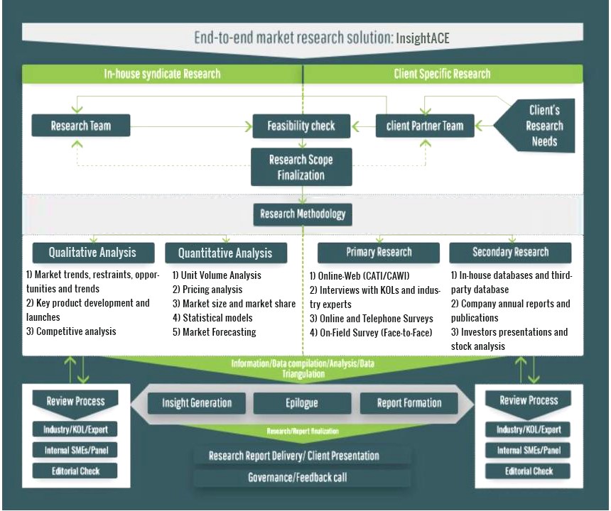
Secondary research
The secondary research sources that are typically mentioned to include, but are not limited to:
The paid sources for secondary research like Factiva, OneSource, Hoovers, and Statista
Primary Research:
Primary research involves telephonic interviews, e-mail interactions, as well as face-to-face interviews for each market, category, segment, and subsegment across geographies
The contributors who typically take part in such a course include, but are not limited to:
Data Modeling and Analysis:
In the iterative process (mentioned above), data models received inputs from primary as well as secondary sources. But analysts working on these models were the key. They used their extensive knowledge and experience about industry and topic to make changes and fine-tuning these models as per the product/service under study.
The standard data models used while studying this market were the top-down and bottom-up approaches and the company shares analysis model. However, other methods were also used along with these – which were specific to the industry and product/service under study.
To know more about the research methodology used for this study, kindly contact us/click here.
